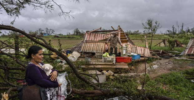
A life-threatening storm surge, catastrophic winds, and floods are predicted to occur across the Florida Peninsula as Hurricane Ian strengthens into a “very hazardous” Category 4 storm with top sustained winds of 140 mph, according to the National Hurricane Center on Wednesday.
As rain bands sweep over Florida, there is also a potential for tornadoes, leading to the issuance of several warnings and watches across the state into Wednesday morning.
Tuesday saw the landfall of Ian, a Category 3 monster that pounded Cuba with 125 mph winds. According to Kevin Guthrie, director of state emergency management, strong winds and storm surges are still predicted to reach further north, into the Tampa Bay area.
A mandatory evacuation order was issued for hundreds of thousands of Floridians as the National Hurricane Center extended its hurricane warning over more than 150 miles of the state’s Gulf Coast. Florida Power & Light issued a warning that widespread power disruptions are likely.
Florida Governor Ron DeSantis stated on Tuesday night that South Florida and the Florida Keys were already experiencing power disruptions.The hurricane’s core was 75 miles west-southwest of Naples at 5 a.m.
According to forecasts, Ian’s core will pass over central Florida on Wednesday night and Thursday morning before reemerging over the western Atlantic by late Thursday.
According to the hurricane center, Central Florida could have howling winds along with 12 to 16 inches of rain, with isolated locations perhaps receiving 2 feet. DeSantis claimed that floods and a “record” storm surge were possible.
DeSantis said on Tuesday that there would be “catastrophic flooding” and “life-threatening storm surge” in certain locations. “The storm is producing a lot of surge due to its magnitude. As this arrives, the Gulf will be furious.”
According to DeSantis, during a press conference Tuesday night, as Ian moved closer to the state, the Florida Keys saw hurricane-force winds and heavy rain late Tuesday.Along the state’s west coast, a storm surge warning is still in place, with the Naples to Sarasota area at the greatest risk.
DeSantis issued a flood warning for parts of west Florida. Additionally, he mentioned the likelihood that after making landfall, a weakened Ian would continue marching through Central Florida until leaving the country on Friday close to Volusia County on the Atlantic coast.
We have a lot of unpleasant weather ahead of us over the next three days, according to DeSantis.
- 8,000 consumers were without power in southeast Florida, and 30,000 utility personnel are ready to assist in the event of a power loss, according to DeSantis.
- 176 emergency shelters have been opened in preparation for floods and property destruction, and additional shelters are anticipated, according to DeSantis.
Tampa May Miss Landfall, But A Major Impact Is Almost Certain
Although Tampa was no longer the most likely location for landfall, the region’s prediction still calls for extremely heavy rain. Tampa will still see storm surge, but not to the extent predicted in early forecasts, according to senior meteorologist Dan Kottlowski of AccuWeather. Furthermore, “it’s quite likely that this thing may wobble” farther north than computer simulations predict.
According to Christianne Pearce, a meteorologist with the meteorological service, the Tampa area’s proximity to the sea makes it particularly susceptible to storm surges.Given how heavily built up certain places are, Pearce said that any amount of storm surge, as well as any inland flooding, could have a big impact there.
Storm Will Weaken And Stay Over Florida. “For Quite Some Time.”
The hurricane will make landfall somewhere between Tampa and Fort Myers, according to FEMA administrator Deanne Criswell, who was addressing a White House briefing. Everyone “has to keep focused,” she added, adding that the entire state will be affected.
Storm surge is the main concern since, by the time Ian hits Florida, the storm will have slowed to about 5 mph, according to her.This is important because it indicates that Floridians will be affected by the storm’s effects for a very long time, she added.
Theme Parks In Florida Are Prepared To Close.
Theme parks in Florida are quickly preparing for their arrival. The first theme park to close in advance of the hurricane was Busch Gardens Tampa Bay, only a few miles from where it was originally predicted that the hurricane would make landfall.
A statement from Universal Orlando Resort to USA TODAY said, “Everything centers on the safety of our visitors and staff members.”
No Need For Evacuees To Go Too Far
Those wishing to escape the storm’s course may not have to travel very far, according to Guthrie.The majority of residents in Southwest Florida should leave the whole state, according to Guthrie. Just travel directly to Broward, Miami-Dade, and Palm Beach across the entire state.
According to DeSantis, going to a nearby higher-ground structure could suit some evacuees.According to DeSantis, “this does not always mean that you must relocate to another state.” We don’t mean to continue going until there is no risk of getting rained on when we announce to evacuate.
Siesta Key In Sarasota County, Waiting For The Storm
Pam and Andrew Trapani decided Tuesday to stay inside their house on Siesta Key to weather Hurricane Ian. The Trapanis considered fleeing as the prediction got worse, but by the time they did, they couldn’t locate a motel.
They decided that their hurricane-resistant home, built in 2017 at the height of 17 feet and with a whole-house generator, was secure enough. It features a bottom floor intended for floodwater to pass through. It is supported by 55 pilings driven 35 feet into the ground.


